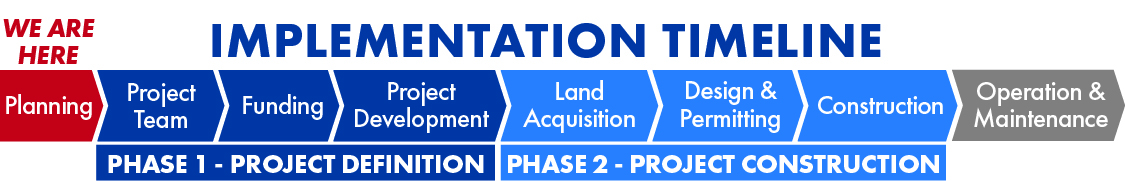
Project Implementation
Now that vulnerabilities to flood hazards have been identified and flood mitigation strategies have been recommended, a clear path to project implementation is needed to move the SJMDP forward. The SJMDP identified
both watershed-wide policies and regional projects that can be implemented within the San Jacinto Watershed to reduce flood risk. The recommendations were categorized
into short-term and long-term solutions:
• Short-term solutions, or additional studies, recommended policy changes, etc., can be implemented within a five-year window, if appropriate funding and partnerships are in place. These typically require less funding and have fewer implementation constraints than the long-term solutions.
• Long-term solutions, or structural solutions, consist of the recommended projects that will take more than five years to complete once implementation begins, due to funding, environmental permitting, construction time, or
other project constraints. The SJMDP has completed the planning phase of developing flood mitigation solutions
in the watershed.
SHORT-TERM SOLUTIONS
• Vision Group – This group would establish a regional entity across county boundaries for continuing to cast a vision for regional project implementation and common drainage criteria throughout the basin. The group could foster collaboration to evaluate the path forward in reducing
vulnerabilities to flood hazards and improving resiliency.
• Policy – While each entity may not need identical drainage criteria, common base criteria would standardize the minimum requirements needed for future development. Policies that could be standardized include detention
methodology, hydrologic and hydraulic methodology, floodplain analysis, and minimum finished floor elevations.
• Conservation Areas – Identify areas along major streams that could be set aside as conservancy areas to
preserve the floodplain and prevent increase in flood risk.
• Flood Monitoring/Warning Enhancements – Adding rainfall and water surface elevation gages to
provide both the emergency managers and the public with additional information to determine flood risk.
• Flood Response – Improve flood response by enhancing communication, identifying and prioritizing improvements to critical infrastructure in flood prone areas,
and developing public education strategies.
• Buyouts – Acquiring property and removing it from potential flood risk is often the most cost-effective
approach. There are over 600 structures identified within the 20% ACE (5-year) storm at an anticipated buyout cost of $190 million. The counties and regional groups
should seek funding to develop a buyout program for these frequently flooded structures.
• Floodplain Re-Mapping – The updated modeling for the existing flood hazard assessment showed that
current elevations and floodplains used within the basin are outdated. The average 1% ACE (100-year) water
surface elevation increased between 0.5 and 4.5 feet in the watershed. This means structures built to current
standards could still be within the 1% ACE and are more susceptible to flooding. Re-mapping the watershed would provide updated flood risk information to agencies and
the public.
• Watershed Protection Studies – Watershed protection studies for each of the watersheds would further
analyze the flooding potential on the tributaries of the major streams and identify local drainage improvements
needed. A recommended priority of studies would begin with Spring Creek, followed by West Fork, Caney Creek,
Peach Creek, Lake Creek, Luce Bayou, and East Fork.
LONG-TERM SOLUTIONS
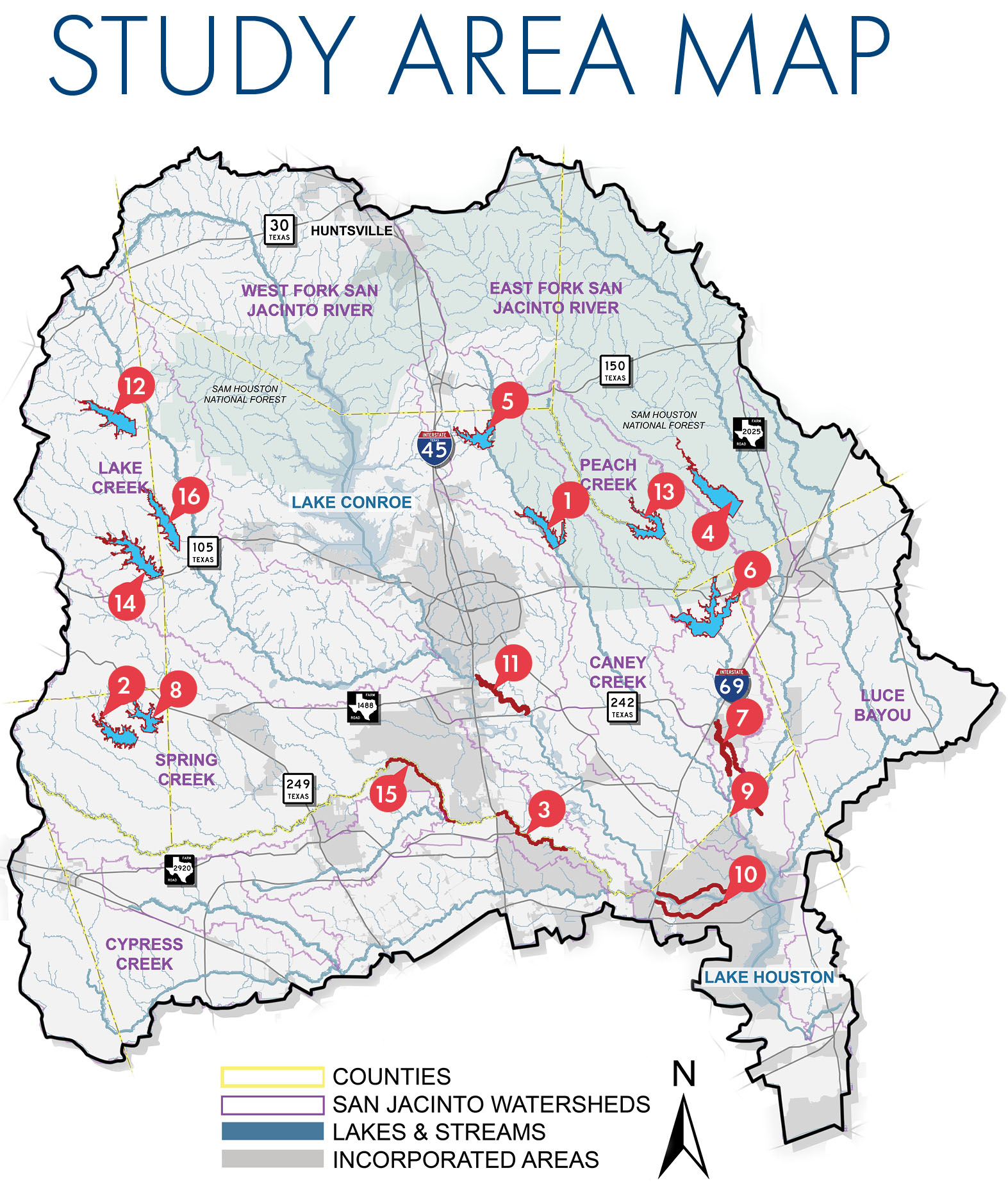
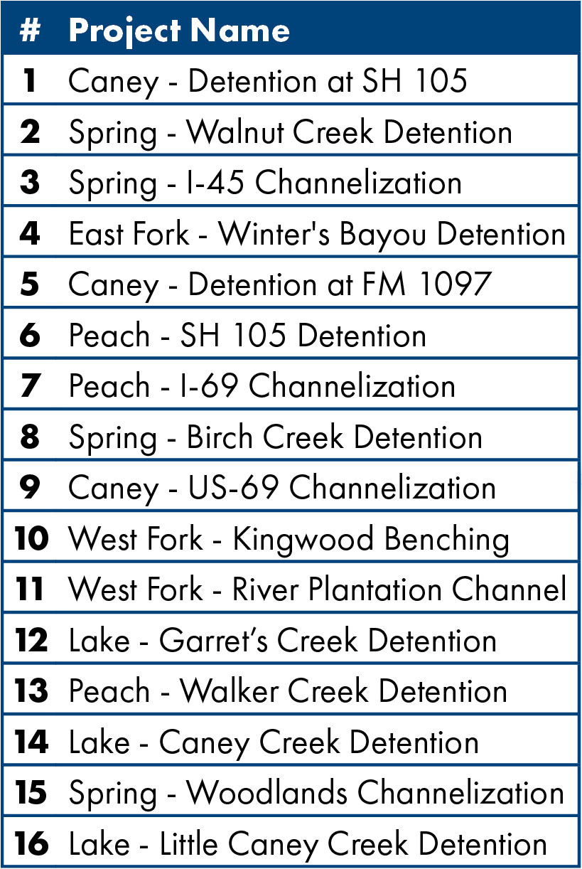
Long-term solutions consist of structural solutions, including:
• Stormwater Detention Basins are excavated, man-made dry dams that capture runoff, detain it, and
release at a slower flow rate. The result is lower water surface elevations downstream. Each detention facility was conceptually designed to provide flood damage reduction benefits along the major streams in the watershed.
• Channel Conveyance Improvements consist of excavating channels to allow for more capacity of flow, thereby reducing the water surface elevations in the vicinity of the project area. Channel conveyance improvements can
range from concrete-lined sections, to man-made channels that incorporate environmentally friendly features.


 The San Jacinto River Regional Watershed Master Drainage Plan (SJMDP) was a comprehensive regional study led by local study partners including the Harris County Flood Control District, Montgomery County, the City of Houston, and the San Jacinto River Authority. The study identified and developed information for communities to use for hazard mitigation planning along the channels included in this study. As extreme weather events and flood waters do not recognize jurisdictional boundaries, like county and city limits, the four study partners worked together to address flooding as a regional issue. This comprehensive study developed a set of hydrologic and hydraulic models for the major streams of the Upper San Jacinto River regional watershed that will provide a technical basis for local, state, and federal agencies to identify flooding vulnerabilities for existing infrastructure and impacts from future growth to improve flood resiliency in the watershed. The models developed for this study used the new Atlas 14 rainfall data, the most current terrain data, and the latest technology to develop a comprehensive model that represents the various streams and their interaction with the San Jacinto River watershed. Potential projects supported by the results of this study are intended to reduce flood risks to people and property located throughout the watershed resulting in better informed and more resilient communities. Information developed includes non-regulatory inundation maps (not intended to replace current FEMA effective Flood Insurance Rate Maps) for the studied streams that show the extent and depth of riverine flooding of the major streams within the watershed for an array of simulated storm events. Additionally, information was gathered about the number of structures, acres of land, properties, and miles of roadway as well as critical infrastructure and evacuation routes, that are located within the inundated areas.
 The goals of the SJMDP were to: